Search Pennsylvania Death Records
 Pennsylvania Newspapers, Full Search (1719-1995), 658 titles
- Pennsylvania Obituary Search - (1981-current)
- Pennsylvania Birth Records Database, (1767-1995)
 |
| Click photo to enlarge |
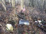
Hook Cemetery
Greene County, Pennsylvania
Lat: 39° 54' 55"N, Lon: 80° 07' 44"W
Franklin Township
Contributed by Brad Jarvis, Dec 26, 2009, last edited Dec 30, 2009 [forza@windstream.net]. Total records = 1.
At the intersection of Route 21 and Route 188 in Waynesburg, turn onto Route 188 (also known locally as the Jefferson Road) and follow for 2.4 miles. Make a sharp left on to Braden Run Road and follow for less than a tenth of a mile. The cemetery is located in the woods to your left just below the road and just before a gas pipeline right-of-way. It will be very difficult to see even during the winter months because it is very small. GPS coordinates will be helpful in locating it.
This cemetery is abandoned and is in no longer maintained. I found two fieldstone markers, one of which has the letter "M" then a heart symbol then either the letter "H" or "M"..
I walked the cemetery on Dec 26, 2009 with my friend Charles Newman. This transcription is complete and includes all existing stones. I also have digital photographs of all the stones as well as many views of the cemetery itself and would share them with anyone interested.
- Brad JarvisHook, James, b. 1749, d. 1834, Captain Co. A 13th Virginia Regiment Revolutionary War, Revolutionary War Flag Marker
Browse More Cemetery Records